BY FELIX BASIIME
KABAROLE: Geological factors have for long challenged efforts by authorities to improve water, sanitation and hygiene (WASH) in Kabarole district.
According to the district chairman, Mr Richard Rwabuhinga, loamy soils composed mainly of sand and silt with a small amount of clay have made it impossible for engineers to build WASH structures. These soils make up about 70 percent of the district, and have caused loss of money in latrines that collapse.
There are over 50 crater lakes spread in Kabarole and Bunyangabu districts and lots of pozollana rock deposits in Fort Portal City, which is evidence that there was high volcanicity in the area.
Ms Olive Tumuhairwe, a Health Inspector, says in Harugongo sub-county, pozzolana rocks made up of volcanic material have made it hard to dig pit latrines and as such residents dig shallow pit latrines.
In other areas such as Karago Town Council, Karangura and Bukuuku there is a high water table which makes constructing latrines difficult since the waste can easily enter into the groundwater or run into rivers and streams when they flood.
A water table is the level at which underground soil and gravel is completely saturated with water. The water table is generally higher in areas with high density soil related to clay content.
According to Tumuhairwe, latrine coverage in the district is at 81 percent “but when we go to standards we go to as below as 15 percent”.
“Digging pit latrines is quite challenging. So we are looking into innovating technologies that can actually suit the area needs like ecosan technology which we are implementing,” she says, adding: “Areas with high water table such as Karago town council, Karangura and Bukuuku challenge the efforts of improving sanitation and hygiene.”
Mr Vincent Mugumya, a resident of Karangura, says: “In lower areas, the water table is high so people dig very shallow latrines and feaces mix with water which means the people downstream drink contaminated water.”
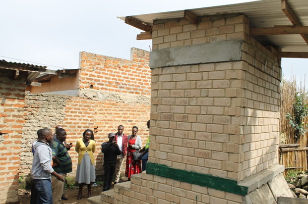
However, since the Natural defense initiative (NRDI) started its community work, most residents are smiling with the new technology of ecosan toilets under which costs are shared.

NRDI is promoting ecosan toilets in Karangura and Bukuuku as well as Karago town council (with a population of 9,772 as per Kabarole Wash Master Plan 2018 to 2030) where this type of toilet is good in such areas.
Mr Chris Amanyire, a Field Officer with NRDI, says their organisation has promoted Ecosan toilets to solve the issues of sanitation under areas faced by high water table.
Ecosan toilets work without water, separating urine from faeces and allowing waste to be recycled by turning it into compost or liquid fertilizer, which can be used to fertilise soil or crops.
“We just open the surface and start construction. The household contributes Shs700,000 and NRDI pays the balance of Shs2.3 million,” Amanyire says.
The chairperson of Karago town council, Mr Bright Patrick Rwankwege, attributed the issue of low latrine coverage to the terrain, reasoning that if one tries to dig three meters down, they find water.
“What we want now is to sensitize the people to construct modern toilets of Ecosan to reduce the risk of diseases,” Rwankwege said.
The National Housing census 2014 indicates that households in Kabarole district without toilets were 2.2 percent while Karago town council was at 3.3 percent.
Collapsed latrines
George Sande Amooti aka Pecasa is the managing director of Pecasa Enterprises in Fort Portal, Kabarole District. He has been in the construction industry for the last 25 years and his work involves construction of roads, buildings, bridges and other works across the country.
His biggest challenge, however, is the loam soils that cover almost the entire district.
“It is more expensive to carry out any construction works in Kabarole than elsewhere in the country due to loam soils and earthquakes,” Sande says.
He says a constructor in Kabarole has to dig deeper to reach the red soil and observes that the government makes the same design for most of the construction work around the country without regard to other factors such as earthquakes, soils, topography. In the end, money is wasted in collapsed bridges, toilets and poor road works.
“Some of the latrines at schools in Kabarole District collapse because the government gives us the same design for the whole country. When works collapse, they claim we carried out shoddy work,” he says.
According to Kabarole District Wash Master Plan 2018-2030, access to water services is low (58 percent) and is less than the national average estimated at 70 percent at the time.
The district master plan indicated that there is a high level of contamination of drinking water sources (64 percent) especially in rural areas. This compromises the quality of water for domestic use.
Topography
Ms Rita Kiteme, a social scientist at the Ministry of Water and Environment, says there is a high level of erosion because of the gradient of hilly areas in some areas like Karangura.
“This has caused siltation of the rivers due to human activities such as cultivating close to River Mpanga,” she says.
The ministry has done some community training on technologies that could minimize issues of erosion such as constructing rain water harvesting trenches and formulating contours where the gradients are very steep.
Erosion and other contamination factors have raised the cost of water treatment at NWSC plant in Fort Portal as the corporation says they use more chemicals to purify the water of contamination.
The NWSC Fort Portal branch manager, Mr Denis Muramuzi says it is at times very expensive for them to filter the polluted water from River Mpanga because it requires a lot of chemicals.
Water resources management
Kabarole is fairly well endowed with water resources, including surface water (crater lakes, river, streams and wetlands) and ground water, and has adequate rainfall. The district’s freshwater resources are vital for sustaining life and the environment.
The current state of water resources in the district can be described “as adequate” (NWRA, 2013). However, some water resource management challenges that have been noted in the district include; Rapid population growth – increasing demand for water, increased demand for water for agricultural production, domestic supply, and industry, degradation of water resources due to urbanization, industrialization, poor land use practices and faecal contamination of drinking water points.
Kabarole at a glance
It is covered by black loams over red sandy clay loams (volcanic soils) and red sandy loams occasionally under laid by soft laterites on the top layer in most parts of the district.Bridges and latrines at times collapse due to the loamy soils which make up about 70 percent of the district.Kabarole in western Uganda has a total area of 1, 814km2 of which 1,569 km2 is covered by arable land and 198km2 by open water and wetlands.
Most valleys have many flowing rivers and streams, a thing that makes farming easy as animals and people have several options on water points and there is almost no dry season throughout the year.
It has 56 crater lakes, meaning that there was a lot of volcanic activity in this area. This also explains why pozzolana, the mineral used in manufacturing cement, has high deposits in Fort Portal. [Source: Kabarole district 5 year development plan (2011-2016).


